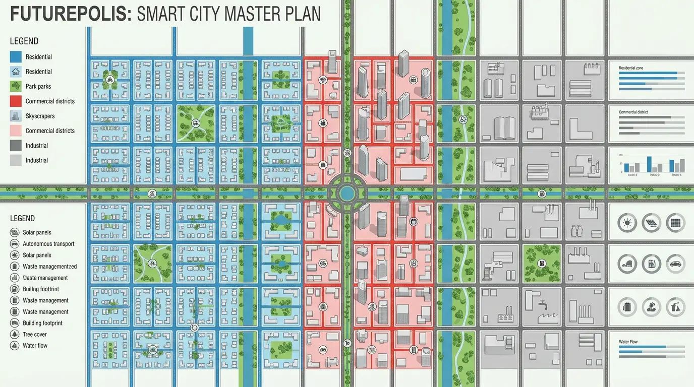
The Dholera master plan is the statutory blueprint for a roughly 920 sq km greenfield industrial smart city on the Gulf of Khambhat coast, of which about 580 sq km is developable. It is delivered through six town-planning schemes (TP1 to TP6), all sanctioned as draft schemes, with Phase-I combining TP1 and TP2 across about 153 sq km. TP2 holds the Activation Area and the ABCD building housing the ICCC. The plan is administered by DSIRDA and phased toward full build-out around 2040.
The Dholera master plan is the statutory blueprint for building a roughly 920 sq km greenfield industrial smart city on the Gulf of Khambhat coast in Gujarat, organised into six town-planning schemes (TP1 to TP6) and phased over about three decades. In simple terms, the master plan is the rulebook that decides where roads, industry, housing, utilities and open space go across the entire Dholera Special Investment Region, and how the city is assembled zone by zone rather than all at once. It is prepared and enforced under the authority of DSIRDA, the region's statutory planning body.
This page explains the structure of the master plan: the total area and how much is developable, the six town-planning schemes and Phase-I, the zones and the Activation Area, the ABCD building at its administrative heart, and the reported role of the consultant Halcrow. Every figure is labelled durable, reported or target, and we stay neutral on developers.
The Dholera master plan covers about 920 sq km (about 580 sq km developable), divided into six town-planning schemes TP1 to TP6, with Phase-I combining TP1 and TP2 across roughly 153 sq km and the Activation Area as the first built zone.
What is the Dholera master plan?
The Dholera master plan is the region-wide development plan that governs land use, infrastructure and phasing across the Special Investment Region. Unlike an ordinary city that grows organically under multiple local bodies, Dholera is planned top-down as a single unit, with the plan dividing the region into industrial, residential, mixed-use, recreation and tourism, and knowledge and IT zones, and setting out the trunk infrastructure that will serve them. The plan is the reason Dholera can bury utilities, reserve transit corridors and lay roads before buildings arrive. It is administered by DSIRDA as the statutory planning authority, and executed on the ground by the SPV DICDL. For the region's overall definition and governance, see our what is Dholera SIR guide.
How big is the area covered by the master plan?
The master plan covers about 920 sq km (roughly 360 sq miles) of total planned area. Of that, about 580 sq km is considered developable, and about 422 sq km is the urban figure reported by DICDL. Importantly, roughly one-third of the developable land falls within the Coastal Regulation Zone, a real constraint given the flat, low-lying coastal terrain. The plan therefore is not simply a grid drawn on empty land; it has to account for tidal flats, drainage and CRZ rules, which is why engineered stormwater systems and graded corridors feature prominently in the built Activation Area.
What are the six town-planning schemes (TP1 to TP6)?
The master plan is delivered through six town-planning schemes, TP1 to TP6, and all six draft schemes have been sanctioned (reported). A town-planning scheme is the legal mechanism, common in Gujarat, by which land is pooled, reconfigured with roads and infrastructure, and returned to owners as serviced final plots, with a share retained for public purposes and to fund development. Phase-I of Dholera combines TP1 and TP2 across roughly 153 sq km. TP1 is about 51 sq km (roughly 12,750 acres); TP2 is about 102 sq km (roughly 25,000 acres) and contains both the Activation Area and the ABCD building; TP5 is about 75 sq km and TP6 about 67 sq km. The areas of TP3 and TP4 are not reliably sourced, so we do not invent them.
| TP scheme | Approx area | Notes | Label |
|---|---|---|---|
| TP1 | about 51 sq km (about 12,750 acres) | Part of Phase-I | reported |
| TP2 | about 102 sq km (about 25,000 acres) | Holds Activation Area and ABCD building | reported |
| TP3 | not reliably sourced | Sanctioned draft scheme | reported (area unknown) |
| TP4 | not reliably sourced | Sanctioned draft scheme | reported (area unknown) |
| TP5 | about 75 sq km | Later-phase scheme | reported |
| TP6 | about 67 sq km | Later-phase scheme | reported |
What is Phase-I of the master plan?
Phase-I combines TP1 and TP2 across roughly 153 sq km, and it is where nearly all real activity is concentrated. TP2 is the more significant of the two because it holds the Activation Area, the plug-and-play demonstration zone, and the ABCD building that houses the region's command centre. Focusing the first phase on these two schemes is a deliberate strategy: prove the model on a manageable footprint with full infrastructure before extending it across the remaining schemes. The phasing of the wider programme, and its target windows, is covered in our Dholera timeline and phases guide.
What zones does the master plan create?
The plan allocates land to a set of functional zones. Qualitatively, these include industrial, residential, mixed-use, recreation and tourism, and a Knowledge and IT Zone, alongside the trunk infrastructure and open space that tie them together. Exact zoning percentages are not reliably sourced, so we describe the zones qualitatively rather than assigning invented shares. The Knowledge and IT Zone in TP2 is notable because it hosts the ABCD building. The industrial zones are where anchors like the semiconductor fab sit, and the planned sectors span defence, aviation, electronics and semiconductors, pharma and biotech, heavy engineering, auto, general manufacturing, agro and food processing, and metals, plus renewables.
What is the Activation Area within the master plan?
The Activation Area is the master plan's proof zone: about 22.5 sq km (NICDC states 22.54) inside TP Scheme 2, developed first as a plug-and-play phase-1 demonstration, roughly 4.25% of the developable land. Its trunk infrastructure is reported built by DICDL, including about 72 km of internal roads, a roughly 50 MLD water treatment plant, underground utilities with smart water meters, a recycled-water network, a 6.5 km stormwater canal and the operational ICCC. The Activation Area is where the master plan stops being a drawing and becomes physical infrastructure. For a full look, see our Dholera Activation Area page.
What is the ABCD building in the master plan?
The ABCD building, short for Administrative cum Business Centre for Dholera, is the administrative heart of the master plan. It sits in the TP2 Knowledge and IT Zone on a plot of about 9 hectares, is designed to LEED Gold standard, and houses the Integrated Command and Control Centre (ICCC), the smart-city brain that monitors water, power, lighting, surveillance, traffic and environment, along with authority offices and a single-window clearance function. It is reported structurally complete and operational, though the exact inauguration date is not documented. In master-plan terms, the ABCD building is the node from which the planned city is meant to be governed and monitored.
Who designed the Dholera master plan?
The master-plan concept is widely attributed to Halcrow, the UK engineering and planning consultancy, though this is reported rather than primary-confirmed, so we present it as such. The involvement of an international planning consultant is often cited in promotion as evidence of the plan's sophistication, and the plan's features, buried utilities, separated water streams, reserved transit corridors and centralised monitoring, are consistent with contemporary greenfield planning practice. Regardless of the consultant, the statutory authority behind the plan is DSIRDA, and the plan's legal force comes from the Gujarat SIR Act, 2009. See our DSIRDA guide for the authority's role.
What are the limits of the master plan today?
A master plan is an intention, and delivery follows in phases, so several honest caveats apply. All six TP schemes are sanctioned on paper, but real infrastructure is concentrated in the Activation Area and Phase-I. Zoning percentages, TP3 and TP4 areas, and precise land-use splits are not reliably sourced. The promotional population and jobs figures, about 1 million residents and 800,000 jobs, are long-range targets tied to the full build-out around 2040, and an earlier 2020 target has lapsed. The plan is genuinely ambitious and partly realised, but reading it as a finished reality rather than a phased blueprint is the common mistake.
How does land pooling work in the master plan?
Land pooling is the engine that turns the master plan into serviced plots, and it is worth understanding because it shapes what a buyer actually receives. Under a town-planning scheme, the authority pools land from many original owners, overlays a planned grid of roads, utilities and open space, and returns to each owner a reconfigured 'final plot' (FP) that is smaller than the original holding but serviced and legally cleaner, with a portion retained by the authority for public infrastructure and to help fund development. The final-plot number and its allotment are meaningful details, because a plot's status within a sanctioned TP scheme affects its legitimacy and its infrastructure access. This mechanism is also why Dholera can plan coherent trunk infrastructure rather than the patchwork that results when land is developed parcel by parcel. It is a Gujarat planning tradition applied here at an unusually large scale.
How does the master plan handle roads and utilities?
The plan front-loads infrastructure, which is a defining feature of a greenfield master plan. In the built Activation Area, DICDL reports an internal road network of about 72 km with carriageways ranging from 18 to 70 m wide, including pedestrian and cycle lanes and a reserved corridor for future rapid transit. Utilities are laid underground, power, ICT and fibre ducts, piped natural gas and potable water with smart meters, so streets are not repeatedly dug up later. Water is managed through a roughly 50 MLD treatment plant, a recycled-water network and separated wastewater lines, with stormwater channelled into a 6.5 km man-made canal. The master plan's logic is to install this skeleton first and let buildings connect to it, the reverse of how organic cities grow.
How does a master-planned city differ from an organic one?
An organic city like most of India's older urban centres grew building by building, with infrastructure chasing demand and often struggling to keep up. A master-planned city like Dholera inverts that sequence: the plan fixes the grid, zones and utilities in advance, and development fills into a predetermined framework. The upside is coherence, buried utilities, reserved corridors, planned drainage for a flood-prone coast. The downside is that a master-planned greenfield city must attract its entire population and economy from scratch, which takes decades and depends on anchors delivering. Neither model is strictly superior; the master plan simply trades the messiness of organic growth for the challenge of populating a pre-built framework.
What does the master plan say about population and jobs?
The plan carries ambitious human targets, but they are long-range and must be labelled as such. The promotional vision for full build-out around 2040 cites about 1 million population and about 800,000 jobs across the region. These are targets tied to the completion of all six schemes, not present figures. An earlier, nearer target of about 120,000 residents and 80,000 jobs by 2020 has lapsed, a useful reminder that master-plan population figures are aspirations contingent on the whole dependency chain of industry, connectivity and housing coming together. Read them as the plan's intent, not as demographic fact.
How should you read a Dholera master-plan map?
When you look at a master-plan map, focus on a few things rather than the impressive whole. Identify which town-planning scheme a location sits in, since TP1 and TP2 are Phase-I and far more developed than later schemes. Note proximity to the Activation Area, the central spine road, and future anchors like the airport, because serviced infrastructure and activity cluster there first. Distinguish sanctioned-and-built zones from sanctioned-but-unbuilt ones. And treat the colourful zone allocations as planning intent whose exact percentages are not reliably sourced. A map shows the plan; only the Activation Area currently shows the plan realised. For deeper geography, the master plan pairs naturally with reading the region's coastal constraints and phasing together.
What are the main critiques of the master plan?
Honest critique strengthens understanding. The plan has faced real friction: land acquisition was litigated, with the Gujarat High Court staying SIR acquisition in 2015 after farmer petitions, and a 2017 Business Standard review found only about 290 of the then 900-plus sq km secured, describing the DMIC broadly as a tale of abandonments and delays. The coastal, CRZ-heavy geography adds cost and complexity. And the gap between a sanctioned plan and a delivered city is wide, with real infrastructure still concentrated in a small fraction of the total area. None of this negates the plan's ambition or its partial delivery; it simply means the master plan should be read as a long-term blueprint with a documented record of slow, contested progress.
The Dholera master plan is best understood as a long-horizon blueprint being executed scheme by scheme, with Phase-I and the Activation Area as the parts that have moved from paper to ground. If you are studying the plan, anchor on what is sanctioned versus what is built, treat zone percentages and unsourced areas with caution, and verify any specific parcel's town-planning scheme and final-plot status before relying on it. The plan is coherent and large; the delivery is partial and phased, and both facts belong in the same sentence.
Frequently asked questions
What does the Dholera master plan cover?
It covers about 920 sq km of total planned area, of which about 580 sq km is developable and about 422 sq km is the reported urban figure. The plan sets out industrial, residential, mixed-use, recreation and tourism, and Knowledge and IT zones, plus trunk infrastructure, across six town-planning schemes administered by DSIRDA.
What are the six TP schemes in Dholera?
Dholera is divided into six town-planning schemes, TP1 to TP6, all sanctioned as draft schemes. TP1 is about 51 sq km, TP2 about 102 sq km (holding the Activation Area and ABCD building), TP5 about 75 sq km and TP6 about 67 sq km. The areas of TP3 and TP4 are not reliably sourced.
What is Phase-I of the master plan?
Phase-I combines TP1 and TP2 across roughly 153 sq km, where nearly all real activity is concentrated. TP2 is central because it contains the Activation Area, the plug-and-play demonstration zone, and the ABCD building with the ICCC command centre. Phase-I proves the model before extending it to the other schemes.
Who designed the Dholera master plan?
The master-plan concept is widely attributed to Halcrow, the UK planning consultancy, though this is reported rather than primary-confirmed. The statutory authority behind the plan is DSIRDA, and its legal force derives from the Gujarat Special Investment Region Act, 2009.
Is the whole Dholera master plan built?
No. All six TP schemes are sanctioned on paper, but real infrastructure is concentrated in the Activation Area and Phase-I. Zoning percentages and the areas of TP3 and TP4 are not reliably sourced, and the population and jobs figures are long-range targets tied to full build-out around 2040, not current reality.
- DSIRDA (dholera.gujarat.gov.in)
- DICDL (dholera.gujarat.gov.in)
- NICDC (nicdc.in)
- Gujarat SIR Act, 2009
- GIDB (gidb.org)
- Wikipedia: Dholera SIR (cross-check)
The free Dholera First-Timer’s Checklist
Fifteen things to verify before you pay a rupee, in one printable PDF. Written for buyers, not brokers.